Israel Modern

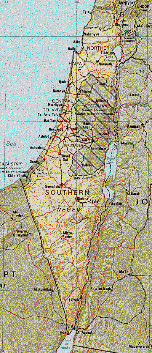
Modern Israel is a country located in the Middle East, bordered by the Mediterranean Sea to the west, Lebanon to the north, Syria to the northeast, Jordan to the east, and Egypt to the southwest. The modern state of Israel was established in 1948, following the end of British rule and the approval of the United Nations partition plan. Today, the country is home to a diverse population of more than 9 million people, with a thriving economy and a rich cultural heritage.

A modern map of Israel shows its major cities, including the capital city of Jerusalem, as well as the major roads, highways, and borders. The country is divided into six administrative districts, each with its own unique character and cultural traditions.

One of the most notable features of modern Israel is its bustling metropolis of Tel Aviv, which is located on the Mediterranean coast and is one of the country's largest cities. Tel Aviv is known for its vibrant arts and cultural scene, as well as its thriving technology and start-up industries.

In addition to its bustling cities, modern Israel is also home to a number of historic sites and natural wonders, including the Dead Sea, the Red Sea, and the Negev Desert. The country is also home to a number of religious and cultural sites of great significance, including the Western Wall, the Church of the Holy Sepulchre, and the Al-Aqsa Mosque.

In conclusion, the modern map of Israel offers a glimpse into the rich history and diverse cultural heritage of this fascinating country. From bustling cities to natural wonders, Israel is a destination that has something for everyone, and is well worth exploring.

You Might Also Like:

Maps

Historical Maps of The WorldHistorical Maps of AfricaHistorical Maps of The AmericasHistorical Maps of AsiaHistorical Maps of Australia and the PacificHistorical Maps of EuropeHistorical Maps of The Middle EastHistorical Maps of Polar Regions and OceansHistorical Maps of Russia and the Former Soviet...
Read More

The Valley of Jezreel and Plain of Esdraelon

The Valley of Jezreel is often identified as comprising only the eastern end of the Plain of Esdraelon, the valley between between Mount Gilboa and the Hill of Moreh and Mount Tabor (see Mount Tabor). However, Jezreel is often used generally to refer to the entire flat and fertile plain stretching s...
Read More

Byzantium And Islam

Byzantium 395 Byzantium at the death of Justinian Byzantium 1000 AD Constantinople Islam at its Height Ottoman Empire 1450-1700 Ottoman Empire 1450-1700...
Read More

Israel

IntroductionIsraelBackground:Following World War II, the British withdrew from their mandate of Palestine, and the UN partitioned the area into Arab and Jewish states, an arrangement rejected by the Arabs. Subsequently, the Israelis defeated the Arabs in a series of wars without ending the deep tens...
Read More

Israel

Map of Israel President: Reuven Rivlin (2014) Prime Minister: Benjamin Netanyahu (2009) Land area: 7,849 sq mi (20,329 sq km); total area: 8,019 sq mi (20,770 sq km) Population (2014 est.): 7,821,850 (growth rate: 1.46%); birth rate: 18.44/1000; infant mortality rate: 3.98/1000; life expectancy: 81....
Read More

China from Mongol rule to the Ming

Ming Dynasty to 1500 Rebellion against Mongol Rule Jiayu Pass, built sometime around the year 1372 after Mongol troops were driven out in 1368. The fortress was strengthened following concern of an invasion by Timur that never came. The Mongols in China were ruling with a great variety of administ...
Read More