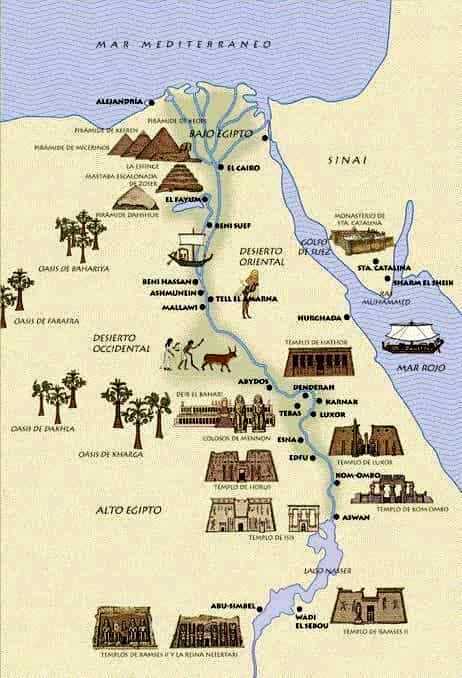
Ancient Egypt had its origin in the course of the Nile River. It reached three periods of great pharaonic splendor: the Ancient Kingdom, the Middle Kingdom and the New Kingdom.
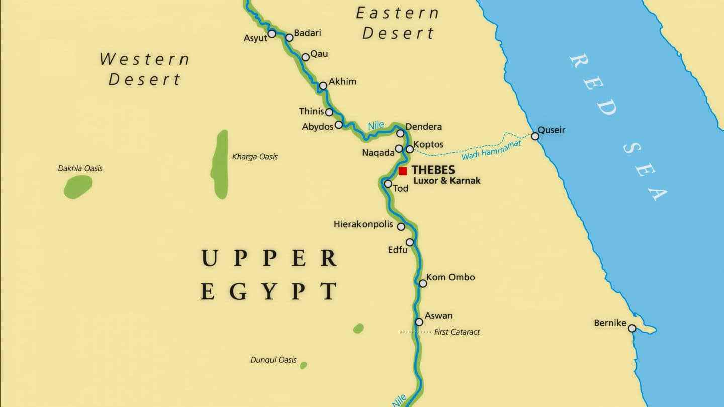
Ancient Egypt map domain stretched from the delta of the Nile in the north, to Elephantine Island, where is the first cataract of the Nile in the south.
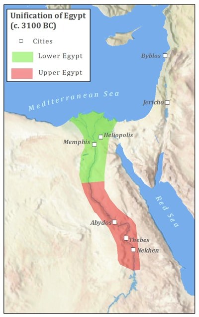
In different periods its expansion reached the eastern desert, the coastline of the Red Sea and the Sinai Peninsula. Formerly it was divided into Upper and Lower Egypt (south and north).
This civilization developed over 3,000 years until the year 31 BC the Roman Empire conquered the Ptolemaic Egypt that ends up disappearing as a state.
The cultural identity began to be diluted after the conquests of the kings of Babylon and Macedonia. In addition, with the arrival of Christianity, ancient Egypt religion disappeared.
The fertile deposits of the Nile River had allowed the Egyptians to practice agriculture in a less laborious way, so that the ancient Egyptians could devote more time to technology, art and cultural development. The State controlled natural and human resources.
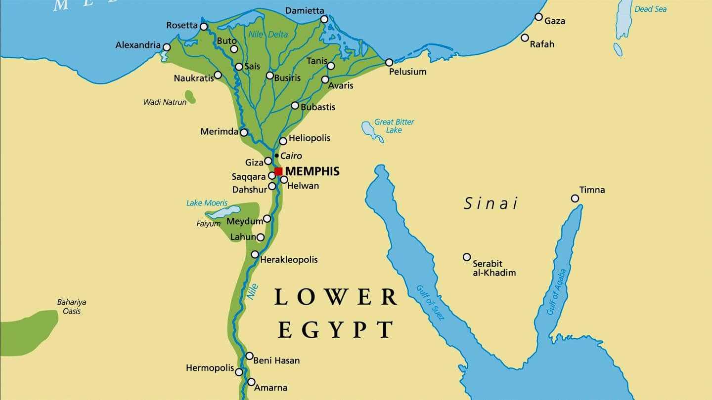
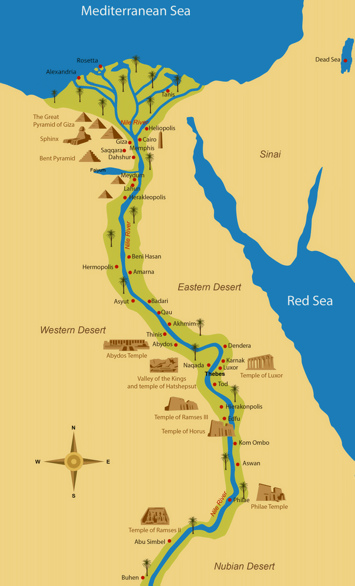
1. Ancient Egypt map: Nile delta.
A delta is a point in the course of a river where it enters a larger water body. It is named a delta when the river subdivides into numerous tributaries as it pours into a larger water body e.g a lake, sea or ocean.
The Ancient Nile delta is approximated to be 90 KM in length and 240 KM in width along the coastline. Overtime, people have been settling around the delta for thousands of years due to its rich agricultural soil deposits.
The ancient Nile delta originally had several tributaries, The tributaries of the Nile delta spread out in a V shape and poured its waters into the Mediterranean sea through the lower part of Egypt.
This area was vastly covered by deposits of silt and was pushed outwards playing a major role in creating an Egyptian boundaries. Nile Delta tributaries were seven in number and spread out from East to West.
The lower part of Egypt was mapped by the Nile delta. Ancient Egyptians relied heavily on the Nile river for a reliable source of water for both agricultural and also for the development of commercial settlements.
Despite the floods experienced along the Nile and its lower parts, the predictability of the Nile waters enabled the Egyptians to plan the growth of crops in time.
In addition to the Nile being a major source of water, it also housed fishes and waterfowl.
Furthermore, canoes and boats were used on the Nile for transportation purposes from one end to another.
2. Map of ancient Egyptian empire.
The Ancient Egyptian empire was formed during the reign of the first Egyptian King. This period was around 31oo BC and occupied the tip of the Nile delta.
It was at this period when the major capital of ancient Egypt was formed.
The ancient Egyptian empire survived relative stability despite periods of transition in leadership, the empire was invaded by foreign powers during its period of slow decline by the command of Alexander the Great.
Greek kingdom ruled Egypt for a long period of time until it was taken over by the Romans.
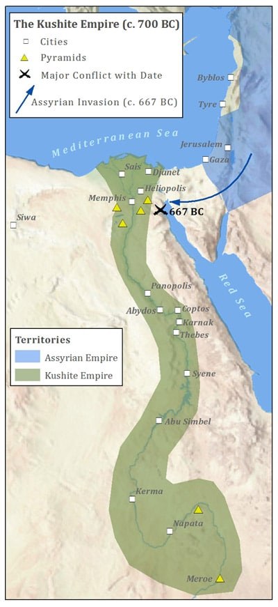
3.Map of ancient Egypt and Nubia.
The north of a Nubia creates the boundary of the upper part of Egypt the Nubian and Egyptians had a long term peaceful relationship mainly because they traded together in commodities such as gold and also engaged in slave trade as a restful of this interaction the people of Egypt conquered the Nubian and thus expanding their territories to the south.
The upper and lower part of Egypt were ruled by different kings up to the time of pharaoh Narmer who unified both upper and lower Egypt, Nubia served as a trade point between the Egyptians and the people of Nubia as a result of greed for trade Egyptians decided to conquer the Nubian so as to control trade boundaries.
Egyptians did this mainly because Nubia was the gateway to acquire African richness and as they were expanding their territories, they built forts and with this it lead to the Nubians being assimilated by the Egyptians.
Ancient Egypt Maps by Time Periods
Early Dynastic Period 2850-2650
1st Dynasty- 2nd Dynasty
The Leaders
Menes-Narmer/ Hor-Aha/ Uagi/ Den / Seth-Peribsen
Civil events
- Unification of Upper and Lower Egypt. Forming a single kingdom.
- Development of the funeral architecture.
- Foundation of Memphis in the boundary between the two parts of the Country.
Military events
- Campaigns against the Nubians
- Extension of the Egyptian territory south of the first cataract
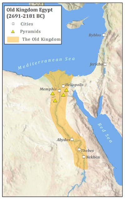
Old Kingdom
3rd Dynasty(2650-2600) – 4th Dynasty(2600-2480)- 5th Dynasty(2480-2350)- 6th Dynasty(2350-2190)
The Leaders
Djoser / Sneferu / Khufu / Menkaure / Userkaf / Sahure / Unas/ Pepi I/ Pepi II
Civil Events
- Construction of the great pyramids
- testimony of a high technical
- artistic level and economic prosperity
- Intensification of commercial relations with the Nubians, Libyans and Semites of the Near East.
- The first religious texts are written, the Texts of the Pyramids with ritual formulas for the cult of the dead.
- Towards the end of the period the autonomy of local authorities and the process of “federalization” of Egypt to the detriment of the authority of the sovereign are accentuated.
Military Events
- Sneferu carries out attacks in Nubia and Libia to fight the invasion and pillage.
- Sahure makes a maritime expedition against Byblos.
- During the region of Pepi I the important campaign against the Syrian-Palestinian tribes take place.
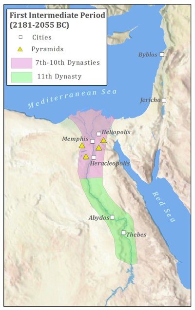
First Intermediate Period 2190-2050
7th Dynasty (Memphis)- 8th Dynasty (Coptic and Abydos)- 9th Dynasty (Heracleopolis)- 10th Dynasty (Heracleopolis)
The Leaders
Khety I / Khety III/ Merikare
Civil Events
- Fracture of the unity of the empire and formation of semiautonomous principalities; formation of local dynasties in Memphis, Copts, Abydos; the sovereign of Heracleopolis predominates over all of them.
- Original literary works flourish, for example: Instructions for King Merikare and dialogue of a man tired of life, with his soul.
Military Events
- Frequent wars between the lords of the various regions (nomos) for achieving supremacy.
- Invasions and incursions from the Near East.
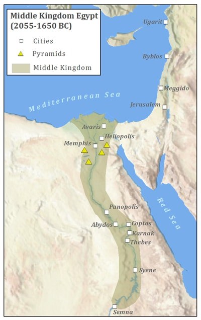
Middle Kingdom 2050-1780
11th Dynasty (2130-1991) – 12th Dynasty (1991-1780)
The Leaders
Mentuhotep I / Amenemhat I/ Sesostris I/ Amenemhat II/ Sesostris II/ Sesostris III/ Amenemhat III/ Amenemhat IV
Civil Events
- Reunification of Egypt under the sovereigns of Thebes.
- The construction of the monumental tombs begins on the eastern bank of the Nile, opposite Thebes (Luxor and Karnak).
- The capital is transferred, stationed in Lisht, the administration is reorganized and power is centralized.
Military Events
- Expeditions of exploration to Sinai and Arabia. Military campaign of Sesostris III in Palestine.
- Conquest of Nubia by Sesostris III.
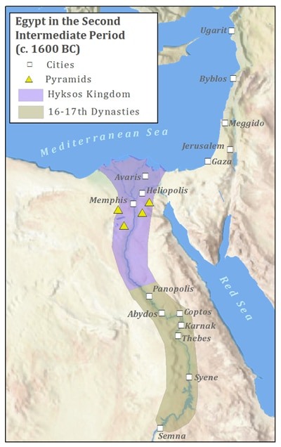
Second Intermediate Period 1780-1560
13th Dynasty (1780-1700) – 14th Dynasty (1780-1700) – 15th Dynasty (1700-1630) – 16th Dynasty (1630-1580) – 16th Dynasty (1610-1560)
The Leaders
Apepi / Seqenenre Tao II/ Kamose / Ahmose I
Civil Events
- Repeated dynastic crises and disintegration of central power.
- Decadence and impoverishment of the country.
- Chaotic situation determined by the invasion of the Hyksos “lords of foreign countries”.
- Awakening of national sentiment and insurrection against the Hyksos.
Military Events
- Invasions of the Hyksos who conquer Lower Egypt and establish their dynasties there.
- Military campaigns against the Hyksos conducted by Seqenenre Tao II sovereign of Thebes who dies fighting.
- Ahmose conquers the capital of the Hyksos, Avaris, and pursues his adversaries to Palestine.
- Expeditions of Ahmose against Syria and Nubia that has returned to become independent.
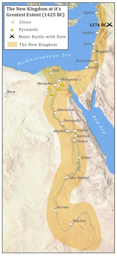
New Kingdom 1560-1085
18th Dynasty (1560-1345) – 19th Dynasty (1345-1220) – 20th Dynasty (1220-1085)
The Leaders
Thutmose I/ Thutmosis II/ Hatshepsut/ Thutmose III/ Amenhotep II/ Thutmose IV/ Amenhotep III / Amenhotep IV (Akhenaten)/ Tutankhamun/ Horemheb/ Seti I / Ramses II/ Merneptah / Ramses III
Civil Events
- The construction of the rupestrian or hypogean tombs begins in the Valley of the Kings.
- Alliance with the king of Mitanni concerted by Thutmosis IV.
- Religious reform ordered by Amenhotep IV (Akhenaten) and centered on the cult of the solar god, Aten, bearer of life.
- Construction of the new capital; Akhetaten, opposition of the Theban clergy and failure of the reform.
- Transfer of the capital Pi-Ramesses to the delta by Ramses II.
Military Events
- Thutmose I, Nubian reconquest.
- Victory of Thutmose III over the local princes in Megiddo and Palestine: Palestine and Syria become Egyptian provinces.
- During the reign of Akhenaten revolts the East.
- Campaigns of Ramses I and Ramses II to conquer Palestine and Syria.
- Battle of Kadesh of uncertain outcome between the Egyptians of Ramses II and the Hittites of Muwatalli. Attempt of invasion of the “People of the Sea” repelled by Ramses II.
Third Intermediate Period 1085-715
21st Dynasty (1085-950) – 22nd Dynasty (950-730) – 23rd Dynasty (817-730) – 24th Dynasty (730-715)
The Leaders
Smendes / Herihor/ Sheshonq I/ Tefnakht/ Bakenrenef
Civil Events
- End of the Egyptian unit.
- Multiplying the independent principalities: towards the middle of the eighth century four local sovereigns claim the title of Pharaoh.
Military Events
- Nubians from the Kush kingdom invade Upper Egypt.
The Late Period 715-332
25th Dynasty (750-656) – 26th Dynasty (663-525) – 27th Dynasty (525-404) – 28th Dynasty (404-398) – 29th Dynasty (398-378) – 30th Dynasty (378-341) – 31st Dynasty (341-332)
The Leaders
Piye / Sabacom/ Tantamani / Psamtik I / Necho / Psamtik II/ Amasis/ Psamtik III/ Amirteo/ Nectanebo II
Civil Events
- Egypt, reunified by the sovereigns of Sais, after the Assyrian domination, experiences an economic renaissance (saita rebirth).
- The construction of a canal between the Nile and Red Sea begins during the reign of Pharaoh Necho.
- Phoenician sailors travel around Africa on account and order of Necho.
Military Events
- The sovereigns of Kush conquer all Egypt and unite Nubia and Egypt in a single kingdom.
- Invasion of the Assyrians and their domination in Egypt.
- Rebellion of Psamtik, prince of Sais, that frees the country from the Assyrians.
- In Pelusio on the delta, Psamtik III is defeated by the Persians, who organize Egypt as a satrapy of his empire.
- The princes of Sais, Mendes and Benito make the last and ephemeral attempts to liberate Egypt from the Persians.
Political Organization in Ancient Egypt
The ancient Egyptian government was characterized by being monarchical, absolutism and theocratic.
The Pharaoh
The government was in the hands of a person called Pharaoh, who lived surrounded by a great court of privileged nobles, officials, priests and warriors.
Pharaoh was the master of all men, owner of all lands and all waters of the Nile. His will was law.
The pharaoh was considered the son of the god Ra (Sun), who had given him power to rule men.
Therefore mortals owed him great reverence and none of them could pronounce his name without adding the following expression :> that life and health flourish in him.
Auxiliary Officials in the Government
Many government functions were delegated to people pharaoh can trust, who provided effective collaboration. Among the main officials:
The Royal Scribe, who was charged with keeping track of agricultural income and inspecting industries and commerce. For this they had to be experts in the handling of numbers and writing.
The Great Vizier, in charge of controlling the provinces, was the intermediary between the authorities and the pharaoh.
The Head of the State Seal, currently compared to the Ministry of Economy, whose function was to monitor the tax revenues and expenses of the State
The Great Priest, who was in charge of religious worship and was concerned with presenting the pharaohs as descendants of the gods.
Writing in Ancient Egypt
The ancient Egyptians wrote with small pointed reeds, dipped in a kind of ink, prepared with water, rubber and plant substances.
They used as paper the papyrus stalks, which grew on the banks of the Nile River.
The Egyptian writing script was deciphered by the Frenchman Jean-François Champollion in 1822.
The key was provided by the discovery of the Rosette Stone in 1799, by the soldier Pierre-François Bouchard, when Napoleon Bonaparte made the expedition to the country of the Nile.
Hieroglyphic writing was a difficult interpretation, as it was formed by signs and images of animals and objects. It was generally used in tombs and temples.
Hieratic Writing is the same hieroglyphic writing but in abbreviated form. Its use was limited to priests and people of great culture.
Demotic Writing is simplified hieratic writing. It was used by the townspeople.
Ancient Egypt Maps